
Sagarmatha topographic map
Interactive map
Click on the map to display elevation.
About this map
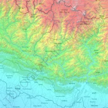
Name: Sagarmatha topographic map, elevation, terrain.
Location: Sagarmatha, Eastern Development Region, Nepal (26.42244 86.13113 28.11375 87.16823)
Average elevation: 1,771 m
Minimum elevation: 52 m
Maximum elevation: 8,836 m
Other topographic maps
Click on a map to view its topography, its elevation and its terrain.
Mahalangur Himal
Nepal > Eastern Development Region > Makalu
Mahalangur Himal, Makalu, Sankhuwasabha, Koshi, Eastern Development Region, Nepal
Average elevation: 4,695 m
Lhotse Shar
Nepal > Eastern Development Region > Khumjung
Lhotse Shar, Khumjung, Solukhumbu, Sagarmatha, Eastern Development Region, Nepal
Average elevation: 7,153 m
Daulatpur
Nepal > Eastern Development Region > Daulatpur
Daulatpur, Saptari, Sagarmatha, Eastern Development Region, Nepal
Average elevation: 122 m
Himalayas
Nepal > Eastern Development Region > Khumjung
Himalayas, Khumjung, Solukhumbu, Sagarmatha, Eastern Development Region, Nepal
Average elevation: 7,555 m
Island Peak
Nepal > Eastern Development Region > Khumjung
Island Peak, Khumjung, Solukhumbu, Sagarmatha, Eastern Development Region, Nepal
Average elevation: 5,461 m
Khumbu Glacier
Nepal > Eastern Development Region > Khumjung > Khumjung
Khumbu Glacier, Khumjung, Solukhumbu, Sagarmatha, Eastern Development Region, Nepal
Average elevation: 6,297 m