
Custer County topographic map
Interactive map
Click on the map to display elevation.
About this map
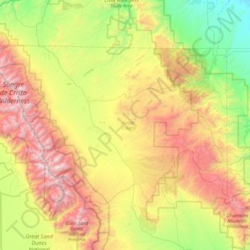
Name: Custer County topographic map, elevation, terrain.
Location: Custer County, Colorado, United States (37.88932 -105.79690 38.26602 -105.04681)
Average elevation: 2,616 m
Minimum elevation: 1,559 m
Maximum elevation: 4,306 m
The county is very rugged and would be virtually inaccessible without roads. The lowest point of the county is around 6,000 feet (1,800 m) in elevation, but most of the county is rugged and mountainous. The county seat of Westcliffe is about 7,800 feet (2,400 m) and along with nearby town Silver Cliff lies in the Wet Mountain Valley which sits at the base of the Sangre de Cristo Mountains. The peaks of the Sangre de Cristo Mountains to the west reach heights in excess of 14,000 feet (4,300 m) with Crestone Peak being the highest at 14,294 feet (4,357 m) and 7th highest fourteener in Colorado.
Other topographic maps
Click on a map to view its topography, its elevation and its terrain.
San Miguel County
San Miguel County, Colorado, United States
Average elevation: 2,357 m
Chaffee County
Chaffee County, Colorado, United States
Average elevation: 3,020 m
La Plata County
La Plata County, Colorado, United States
Average elevation: 2,527 m
Costilla County
Costilla County, Colorado, United States
Average elevation: 2,655 m