
Augusta County topographic map
Interactive map
Click on the map to display elevation.
About this map
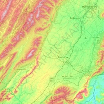
Name: Augusta County topographic map, elevation, terrain.
Location: Augusta County, Virginia, United States of America (37.88586 -79.53328 38.48059 -78.75125)
Average elevation: 570 m
Minimum elevation: 170 m
Maximum elevation: 1,342 m
Other topographic maps
Click on a map to view its topography, its elevation and its terrain.
Saltville
United States of America > Virginia > Saltville
Saltville, Smyth County, Virginia, 24370, United States of America
Average elevation: 617 m
Arlington County
United States of America > Virginia
Arlington County, Virginia, United States of America
Average elevation: 54 m
Smyth County
United States of America > Virginia
Smyth County, Virginia, United States of America
Average elevation: 852 m