
Kenai Peninsula topographic map
Interactive map
Click on the map to display elevation.
About this map
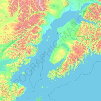
Name: Kenai Peninsula topographic map, elevation, terrain.
Location: Kenai Peninsula, Alaska, United States (58.64501 -154.74877 61.42816 -148.56237)
Average elevation: 370 m
Minimum elevation: -1 m
Maximum elevation: 3,351 m
Other topographic maps
Click on a map to view its topography, its elevation and its terrain.
Northwest Arctic
Northwest Arctic, Alaska, United States
Average elevation: 296 m
Denali National Park and Preserve
United States > Alaska > Cantwell
Denali National Park and Preserve, Windy Creek Trail, Cantwell, Denali, Alaska, United States
Average elevation: 777 m