
Kukës County topographic map
Interactive map
Click on the map to display elevation.
About this map
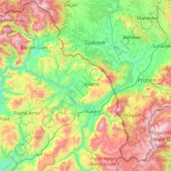
Name: Kukës County topographic map, elevation, terrain.
Location: Kukës County, Northern Albania, Albania (41.81476 19.79823 42.55915 20.62659)
Average elevation: 931 m
Minimum elevation: 164 m
Maximum elevation: 2,705 m
Other topographic maps
Click on a map to view its topography, its elevation and its terrain.
Dibër County
Dibër County, Northern Albania, Albania
Average elevation: 914 m
Shkoder
Albania > Northern Albania > Shkoder
Shkoder, Shkodër Municipality, Shkodër County, Northern Albania, 4001-4007, Albania
Average elevation: 47 m