
JJY topographic map
Interactive map
Click on the map to display elevation.
About this map
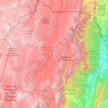
Name: JJY topographic map, elevation, terrain.
Location: JJY, Argentina (-24.61721 -67.21292 -21.78117 -64.15067)
Average elevation: 3,163 m
Minimum elevation: 297 m
Maximum elevation: 6,116 m
Other topographic maps
Click on a map to view its topography, its elevation and its terrain.
Almirante Brown
Argentina > JJY > San Salvador de Jujuy
Almirante Brown, San Salvador de Jujuy, Municipio de San Salvador de Jujuy, Departamento Doctor Manuel Belgrano, JJY, Argentina
Average elevation: 1,230 m
Cerro Torre
Cerro Torre, Municipio de Abra Pampa, Departamento Cochinoca, JJY, Argentina
Average elevation: 4,569 m