
Make a donation
Karachi Division topographic map
Click on the map to display elevation.
Make a donation
Karachi Division
Karachi lies very close to a major fault line, where the Indian tectonic plate meets the Arabian tectonic plate. Within the city of Karachi are two small ranges: the Khasa Hills and Mulri Hills, which lie in the northwest and act as a barrier between North Nazimabad and Orangi. Karachi's hills are barren and are part of the larger Kirthar Range, and have a maximum elevation of 528 metres (1,732 feet).
Make a donation
About this map
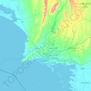
Name: Karachi Division topographic map, elevation, terrain.
Location: Karachi Division, Pakistan (24.42735 66.28623 25.67680 67.58278)
Average elevation: 89 m
Minimum elevation: -2 m
Maximum elevation: 1,065 m
Make a donation
Other topographic maps
Click on a map to view its topography, its elevation and its terrain.
Karachi
Pakistan > Sindh > Karachi South District > Saddar Town
Karachi lies very close to a major fault line, where the Indian tectonic plate meets the Arabian tectonic plate. Within the city of Karachi are two small ranges: the Khasa Hills and Mulri Hills, which lie in the northwest and act as a barrier between North Nazimabad and Orangi. Karachi's hills are barren and…
Average elevation: 20 m
Islamabad
Pakistan > Islamabad Capital Territory
Islamabad is located at 33°26′N 73°02′E / 33.43°N 73.04°E / 33.43; 73.04 at the northern edge of the Pothohar Plateau and at the foot of the Margalla Hills in Islamabad Capital Territory. Its elevation is 540 metres (1,770 ft). The modern capital and the ancient Gakhar city of Rawalpindi form…
Average elevation: 666 m
Make a donation
K2
Pakistan > Gilgit-Baltistan > Shigar District
K2 is the only 8,000+ metre peak that has never been climbed from its eastern face. Ascents have almost always been made in July and August, which are typically the warmest times of the year; K2's more northern location makes it more susceptible to inclement and colder weather. The peak has now been climbed by…
Average elevation: 7,474 m
Make a donation
Make a donation
Murree
Pakistan > Punjab > Murree District
Murree (Punjabi, Urdu: مری) is a mountain resort city, located in the Galyat region of the Pir Panjal Range, within the Muree District of Punjab, Pakistan. It forms the outskirts of the Islamabad-Rawalpindi metropolitan area, and is about 30 km (19 mi) northeast of Islamabad. It has average altitude of…
Average elevation: 1,718 m
Make a donation
Khyber Pakhtunkhwa
Most precipitation falls as thunderstorms or snow during winter and spring, so that the climate at the lowest elevations is classed as Mediterranean (Csa), continental Mediterranean (Dsa) or semi-arid (BSk). Summers are extremely dry in the north of Chitral district and receive only a little rain in the south…
Average elevation: 2,135 m
Make a donation
Make a donation
Saltoro Kangri
Pakistan > Gilgit-Baltistan > Ghanche District
The mountain underwent reconnaissance by Fanny Bullock Workman and her husband in 1911-12. The initial endeavor to conquer the peak, which was then denoted as "Peak 36," took place in 1935, led by a British expedition headed by James Waller and John Hunt. Hunt's involvement in the expedition had been suggested…
Average elevation: 6,651 m
Make a donation
Zhob
Pakistan > Balochistan > Zhob District
Zhob has a semi-arid climate (Köppen BSh). Its rainfall is high enough to avoid the arid climate category found at lower elevations. Zhob receive rainfall on occasions from the monsoon, though this occurs very erratically.
Average elevation: 1,569 m
Skardu
Pakistan > Gilgit-Baltistan > Skardu District
Skardu (Balti: སྐར་མདོ་་; Urdu: سکردو, romanized: skardū, pronounced [skərduː]) is a city located in Pakistani-administered Gilgit−Baltistan in the disputed Kashmir region. Skardu serves as the capital of Skardu District and the Baltistan Division. It is situated at an average…
Average elevation: 3,448 m
Make a donation
Make a donation
Dera Ismail Khan
Pakistan > Khyber Pakhtunkhwa > Dera Ismail Khan District
D. I Khan is situated at an altitude of 177 metres above sea level.
Average elevation: 177 m
Make a donation
Swat
Pakistan > Khyber Pakhtunkhwa > Charsadda District > بانڈہ سیداں > بِجلۍ کورونه
Average elevation: 370 m
Masherbrum
Pakistan > Gilgit-Baltistan > Shigar District
Masherbrum (Urdu: مشہ بروم ; formerly known as K1) is a mountain located in the Ghanche District in the Gilgit Baltistan region of Pakistan. With an elevation of 7,821 metres (25,659 feet), it ranks as the 22nd highest mountain globally and the 9th highest in Pakistan. It holds the distinction of being…
Average elevation: 6,469 m
Make a donation
Make a donation
Make a donation
Make a donation
Make a donation
Make a donation
Make a donation
Make a donation
Zargirandeh
Pakistan > Khyber Pakhtunkhwa > Chitrāl District > Chitral Tehsil
Average elevation: 2,043 m
Make a donation
Make a donation
Dir
Pakistan > Khyber Pakhtunkhwa > Upper Dir District
The topography of Upper Dir is dominated by high mountains. The most important mountain range is the Hindu Kush. It runs from north east to south west along the northern borders with Chitral District. In winter whole area remains snow-covered. The mountains in the western part of the district are covered with…
Average elevation: 2,204 m
Mullazai
Pakistan > Khyber Pakhtunkhwa > Peshāwar District > Peshawar City Tehsil
Average elevation: 347 m
K2
Pakistan > Gilgit-Baltistan > Shigar District
K2 is nicknamed "The King of Mountains" and "The Mountaineers' Mountain", as well as "The Mountain of Mountains", a phrase popularized by Italian climber Reinhold Messner in his book on K2. Although the summit of Everest is at a higher altitude, K2 is a more difficult and dangerous climb. This is in part due…
Average elevation: 7,474 m
Make a donation
Make a donation
Kohat
Pakistan > Khyber Pakhtunkhwa > Kohat District
Kohat city is located at an altitude of 489 metres (1,604 ft). Kohat Pass lies to the north. It is situated on the left bank of the Toi river at a point where after running nearly due east for 50 miles (80 km), it turns to the south. The total area of the district is 2,545 square kilometres (983 sq mi)
Average elevation: 722 m
Make a donation
Chitral
Pakistan > Khyber Pakhtunkhwa > Chitrāl District
The city has an average elevation of 1,500 m (4,921 ft).
Average elevation: 2,982 m
Dir
Pakistan > Khyber Pakhtunkhwa > Upper Dir District
The topography of Upper Dir is dominated by high mountains. The most important mountain range is the Hindu Kush. It runs from north east to south west along the northern borders with Chitral District. In winter whole area remains snow-covered. The mountains in the western part of the district are covered with…
Average elevation: 2,204 m
Make a donation
Quetta
Quetta (/ˈkwɛtə/; Urdu: کوئٹہ; [ˈkweːʈə] (listen); Pashto: کوټه) is the tenth most populous city in Pakistan with a population of over 1.1 million. It is situated in south-west of the country close to the International border with Afghanistan. It is the capital of the province of Balochistan…
Average elevation: 1,968 m
Make a donation