
Ilha do Pico topographic map
Interactive map
Click on the map to display elevation.
About this map
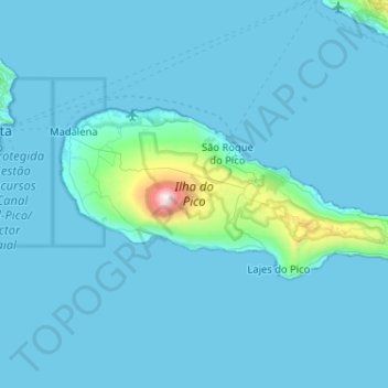
Name: Ilha do Pico topographic map, elevation, terrain.
Location: Ilha do Pico, Azores, Portugal (38.38207 -28.54196 38.56143 -28.02820)
Average elevation: 104 m
Minimum elevation: 0 m
Maximum elevation: 2,279 m
Other topographic maps
Click on a map to view its topography, its elevation and its terrain.