
Sonora topographic map
Interactive map
Click on the map to display elevation.
Sonora
Sonora's natural geography is divided into three parts: the Sierra Madre Occidental in the east of the state; plains and rolling hills in the center; and the coast on the Gulf of California. It is primarily arid or semiarid deserts and grasslands, with only the highest elevations having sufficient rainfall to support other types of vegetation.
About this map
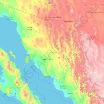
Name: Sonora topographic map, elevation, terrain.
Location: Sonora, Mexico (26.29702 -115.05302 32.49408 -108.42427)
Average elevation: 761 m
Minimum elevation: -2 m
Maximum elevation: 3,030 m
Other topographic maps
Click on a map to view its topography, its elevation and its terrain.