
Thank you for supporting this site ❤️
Make a donation
Make a donation
Santa topographic map
Click on the map to display elevation.
Thank you for supporting this site ❤️
Make a donation
Make a donation
Santa
The topography of the municipality is undulating to rolling with slope ranging from 0-30%.
Thank you for supporting this site ❤️
Make a donation
Make a donation
About this map
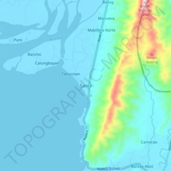
Name: Santa topographic map, elevation, terrain.
Location: Santa, Ilocos Sur, Ilocos Region, 2703, Philippines (17.44599 120.39454 17.52599 120.47454)
Average elevation: 75 m
Minimum elevation: -1 m
Maximum elevation: 605 m
Thank you for supporting this site ❤️
Make a donation
Make a donation