
League City topographic map
Interactive map
Click on the map to display elevation.
About this map
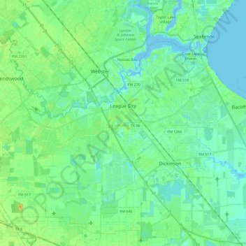
Name: League City topographic map, elevation, terrain.
Location: League City, Galveston County, Texas, 77573, United States (29.42775 -95.22547 29.55908 -94.99763)
Average elevation: 7 m
Minimum elevation: -4 m
Maximum elevation: 23 m
Other topographic maps
Click on a map to view its topography, its elevation and its terrain.
Texas City
United States > Texas > Galveston County
Texas City, Galveston County, Texas, United States
Average elevation: 2 m
Max's Creek
United States > Texas > Galveston County > Friendswood
Max's Creek, West Ranch, Friendswood, Galveston County, Texas, United States
Average elevation: 10 m
Dickinson
United States > Texas > Galveston County
Dickinson, Galveston County, Texas, 77539, United States
Average elevation: 6 m
League City
United States > Texas > Galveston County > League City > League City
League City, Galveston County, Texas, 77573, United States
Average elevation: 7 m
Kemah
United States > Texas > Galveston County > Kemah
Kemah, Galveston County, Texas, United States
Average elevation: 5 m
Galveston
United States > Texas > Galveston County > Galveston
Galveston, Galveston County, Texas, 77553, United States
Average elevation: 1 m
Galveston
United States > Texas > Galveston County
Galveston, Galveston County, Texas, United States
Average elevation: 1 m
Friendswood
United States > Texas > Galveston County
Friendswood, Galveston County, Texas, 77546, United States
Average elevation: 11 m