
Saratoga County topographic map
Interactive map
Click on the map to display elevation.
About this map
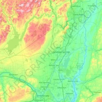
Name: Saratoga County topographic map, elevation, terrain.
Location: Saratoga County, New York, United States of America (42.77546 -74.16010 43.39797 -73.57327)
Average elevation: 218 m
Minimum elevation: 3 m
Maximum elevation: 833 m
Saratoga County is situated in the eastern portion of New York, north of Albany, northwest of Troy, and east of Utica. According to the U.S. Census Bureau, the county has a total area of 844 square miles (2,190 km2), of which 810 square miles (2,100 km2) are land and 34 square miles (88 km2) (4.0%) are covered by water. The Hudson River forms the eastern border of the county, while the Mohawk River demarcates its southern border. The highest elevation in Saratoga County is at the peak of Tennet Mountain in the Adirondack Mountains, at 2,759 ft (841 m), while the lowest elevation is 69 ft (21 m), at the waterfront of the Village of Waterford, at the confluence of the Mohawk and Hudson Rivers.
Other topographic maps
Click on a map to view its topography, its elevation and its terrain.
Farmingville
United States of America > New York
Farmingville, Suffolk County, New York, 11738, United States of America
Average elevation: 47 m
Queens
United States of America > New York > New York
Queens, New York, United States of America
Average elevation: 11 m
Saint Lawrence
United States of America > New York
Saint Lawrence, New York, United States of America
Average elevation: 239 m
Essex County
United States of America > New York
Essex County, New York, United States of America
Average elevation: 418 m
Nassau County
United States of America > New York
Nassau County, New York, United States of America
Average elevation: 18 m
Allegany County
United States of America > New York
Allegany County, New York, United States of America
Average elevation: 561 m
Valley Stream
United States of America > New York > Valley Stream > Valley Stream
Valley Stream, Hempstead, Nassau County, New York, 11580, United States of America
Average elevation: 7 m
New York County
United States of America > New York > New York
New York County, New York, United States of America
Average elevation: 16 m