
Store memurutinden topographic map
Interactive map
Click on the map to display elevation.
About this map
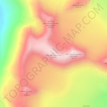
Name: Store memurutinden topographic map, elevation, terrain.
Location: Store memurutinden, Lom, Oppland, Norway (61.56720 8.47758 61.56730 8.47768)
Average elevation: 2,043 m
Minimum elevation: 1,558 m
Maximum elevation: 2,359 m
Other topographic maps
Click on a map to view its topography, its elevation and its terrain.
Finnmark
Finnmark, Bamble, Vestfold og Telemark, 3967, Norway
Average elevation: 38 m
Øvre Engesland
Øvre Engesland, Birkenes, Agder, 4768, Norway
Average elevation: 355 m
Gihtsejiegŋa
Gihtsejiegŋa, Nordkalottruta, Tysfjord, Nordland, Norway
Average elevation: 1,096 m
Vetle Skagastølstind
Vetle Skagastølstind, Luster, Sogn og Fjordane, Norway
Average elevation: 1,783 m
Jesus Lever-steinen
Jesus Lever-steinen, Løvstien, Solheims Boretslag, Solheim, Årstad, Gyldenpris, Bergen, Hordaland, 5057, Norway
Average elevation: 100 m
Folgefonna
Folgefonna, Gardshammar, Kvinnherad, Hordaland, Norway
Average elevation: 709 m