
Ingham County topographic map
Interactive map
Click on the map to display elevation.
About this map
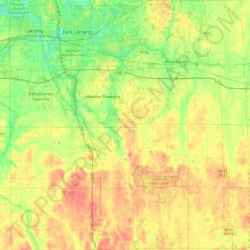
Name: Ingham County topographic map, elevation, terrain.
Location: Ingham County, Michigan, United States of America (42.42196 -84.60314 42.77660 -84.14060)
Average elevation: 278 m
Minimum elevation: 246 m
Maximum elevation: 319 m
The county consists of gently rolling hills with an elevation ranging between 800 and 1,000 feet above sea level. The highest point in the county is the top of Teaspoon Hill rising to a height of 1,056 feet above sea level 1.5 miles north of Leslie.
Other topographic maps
Click on a map to view its topography, its elevation and its terrain.
Genesee County
United States of America > Michigan
Genesee County, Michigan, United States of America
Average elevation: 246 m
Ontonagon County
United States of America > Michigan
Ontonagon County, Michigan, United States of America
Average elevation: 334 m
Sanilac County
United States of America > Michigan
Sanilac County, Michigan, United States of America
Average elevation: 228 m
East Lansing
United States of America > Michigan > East Lansing > East Lansing
East Lansing, Ingham County, Michigan, United States of America
Average elevation: 261 m