
Kongo Central topographic map
Interactive map
Click on the map to display elevation.
About this map
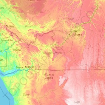
Name: Kongo Central topographic map, elevation, terrain.
Location: Kongo Central, Democratic Republic of the Congo (-6.07822 12.03907 -4.27824 16.26751)
Average elevation: 340 m
Minimum elevation: -1 m
Maximum elevation: 1,268 m
Other topographic maps
Click on a map to view its topography, its elevation and its terrain.
Katanga
Democratic Republic of the Congo
Katanga, Democratic Republic of the Congo
Average elevation: 1,008 m
Bandundu
Democratic Republic of the Congo
Bandundu, Democratic Republic of the Congo
Average elevation: 555 m
Mambwe
Democratic Republic of the Congo > Tanganyika
Mambwe, Tanganyika, Democratic Republic of the Congo
Average elevation: 769 m
Kinshasa
Democratic Republic of the Congo
Kinshasa, Democratic Republic of the Congo
Average elevation: 513 m
Kasai
Democratic Republic of the Congo
Kasai, Democratic Republic of the Congo
Average elevation: 609 m
Lukulu
Democratic Republic of the Congo > Maniema
Lukulu, Pangi, Maniema, Democratic Republic of the Congo
Average elevation: 557 m
Lake Tanganyika
Democratic Republic of the Congo
Lake Tanganyika, Democratic Republic of the Congo
Average elevation: 1,064 m
Kwango
Democratic Republic of the Congo > Kwango
Kwango, Democratic Republic of the Congo
Average elevation: 587 m
Tanganyika
Democratic Republic of the Congo > Tanganyika
Tanganyika, Democratic Republic of the Congo
Average elevation: 1,038 m
Lower Uele
Democratic Republic of the Congo > Lower Uele
Lower Uele, Democratic Republic of the Congo
Average elevation: 527 m
Kasai-Oriental
Democratic Republic of the Congo
Kasai-Oriental, Democratic Republic of the Congo
Average elevation: 713 m
Tshopo
Democratic Republic of the Congo > Tshopo
Tshopo, Democratic Republic of the Congo
Average elevation: 514 m
North Kivu
Democratic Republic of the Congo > North Kivu
North Kivu, Democratic Republic of the Congo
Average elevation: 1,069 m
Luapula
Democratic Republic of the Congo > Haut-Katanga > Luapula
Luapula, Kenya, Kipushi, Haut-Katanga, Democratic Republic of the Congo
Average elevation: 1,201 m
Kinshasa
Democratic Republic of the Congo > Kinshasa
Kinshasa, Aketi, Kinshasa, Democratic Republic of the Congo
Average elevation: 316 m
Tshopo
Democratic Republic of the Congo > Tshopo
Tshopo, Democratic Republic of the Congo
Average elevation: 529 m
Haut-Katanga
Democratic Republic of the Congo > Haut-Katanga
Haut-Katanga, Democratic Republic of the Congo
Average elevation: 1,174 m
Kolwezi
Democratic Republic of the Congo > Lualaba > Kolwezi
Kolwezi, Lwalaba, Lualaba, Democratic Republic of the Congo
Average elevation: 1,429 m
Haut-Lomami
Democratic Republic of the Congo > Haut-Lomami
Haut-Lomami, Democratic Republic of the Congo
Average elevation: 897 m
Ituri Province
Democratic Republic of the Congo > Ituri Province
Ituri Province, Democratic Republic of the Congo
Average elevation: 958 m
Nsenga
Democratic Republic of the Congo > Tanganyika > Nsenga
Nsenga, Tanganyika, Democratic Republic of the Congo
Average elevation: 1,601 m
Ndolo
Democratic Republic of the Congo > Kinshasa > Ndolo
Ndolo, Barumbu, Lukunga, Kinshasa, Democratic Republic of the Congo
Average elevation: 276 m
Bunia
Democratic Republic of the Congo > Ituri > Bunia
Bunia, Irumu, Orientale, Ituri, Democratic Republic of the Congo
Average elevation: 1,271 m