
Saudi Arabia topographic map
Interactive map
Click on the map to display elevation.
About this map
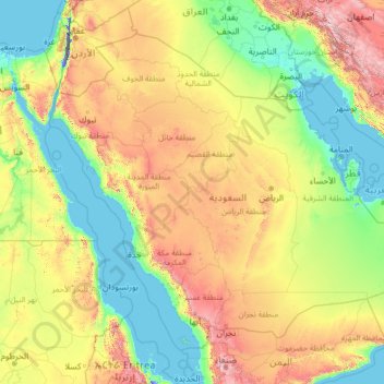
Name: Saudi Arabia topographic map, elevation, terrain.
Location: Saudi Arabia (16.29000 34.45717 32.15434 55.66669)
Average elevation: 551 m
Minimum elevation: -415 m
Maximum elevation: 3,894 m
Saudi Arabia's diverse geography is dominated by the Arabian Desert, associated semi-desert, shrubland, steppes, several mountain ranges, volcanic lava fields and highlands. The 647,500 km2 (250,001 sq mi) Rub' al Khali ("Empty Quarter") in the southeastern part of the country is the world's largest contiguous sand desert. Though there are lakes in the country, Saudi Arabia is the largest country in the world by area with no permanent rivers. Wadis, non-permanent rivers, however, are very numerous. The fertile areas are to be found in the alluvial deposits in wadis, basins, and oases. The main topographical feature is the central plateau which rises abruptly from the Red Sea and gradually descends into the Nejd and toward the Persian Gulf. On the Red Sea coast, there is a narrow coastal plain, known as the Tihamah parallel to which runs an imposing escarpment. The southwest province of Asir is mountainous, and contains the 3,133 m (10,279 ft) Mount Sawda, which is the highest point in the country. Saudi Arabia is home to more than 2000 dormant volcanoes. Lava fields in Hejaz, known locally by their Arabic name of harrat (the singular is harrah), form one of Earth's largest alkali basalt regions, covering some 180,000 square kilometres (69,000 sq mi), an area greater than the state of Missouri.
Other topographic maps
Click on a map to view its topography, its elevation and its terrain.
Saint Croix
United States of America (USVI Saint Croix) > United States Virgin Islands
Saint Croix, Saint Croix District, United States Virgin Islands, United States of America (USVI Saint Croix)
Average elevation: 11 m
Victoria Falls
Zambia > Southern Province > Livingstone
Victoria Falls, Livingstone, Livingstone District, Southern Province, Zambia
Average elevation: 875 m
Tegernsee
Germany > Bavaria > Landkreis Miesbach
Tegernsee, Landkreis Miesbach, Bavaria, 83684, Germany
Average elevation: 858 m
Silver Bay
Canada > Manitoba > Division No. 19 > Unorganized Division No. 19
Silver Bay, Unorganized Division No. 19, Division No. 19, Manitoba, Canada
Average elevation: 248 m
Samfya
Samfya, Samfya District, Luapula Province, Zambia
Average elevation: 1,181 m
Gornji Vakuf-Uskoplje
Bosnia and Herzegovina > Federation of Bosnia and Herzegovina
Gornji Vakuf-Uskoplje, Gornji Vakuf-Uskoplje municipality, Central Bosnia Canton, Federation of Bosnia and Herzegovina, 70240, Bosnia and Herzegovina
Average elevation: 869 m
Oborci
Bosnia and Herzegovina > Federation of Bosnia and Herzegovina
Oborci, Donji Vakuf Municipality, Central Bosnia Canton, Federation of Bosnia and Herzegovina, 70220, Bosnia and Herzegovina
Average elevation: 807 m
Donji Vakuf
Bosnia and Herzegovina > Federation of Bosnia and Herzegovina
Donji Vakuf, Donji Vakuf Municipality, Central Bosnia Canton, Federation of Bosnia and Herzegovina, 70220, Bosnia and Herzegovina
Average elevation: 694 m
Beer Lake
Canada > Ontario > Haliburton County > Minden Hills
Beer Lake, Minden Hills, Haliburton County, Central Ontario, Ontario, Canada
Average elevation: 341 m
Silver Bay
United States > Minnesota > Lake County
Silver Bay, Lake County, Minnesota, United States
Average elevation: 247 m
Walkersville
United States > Maryland > Frederick County
Walkersville, Frederick County, Maryland, 21793, United States
Average elevation: 99 m
Al Azhar Park
Al Azhar Park, El-Darb El-Ahmar, Cairo, Egypt
Average elevation: 53 m
Rangiroa
France > French Polynesia > Rangiroa
Rangiroa, Tuamotu-Gambier, French Polynesia, 98775, France
Average elevation: 0 m
Royal Borough of Greenwich
United Kingdom > England > London
Royal Borough of Greenwich, London, Greater London, England, United Kingdom
Average elevation: 32 m
Gwembe
Gwembe, Gwembe District, Southern Province, Zambia
Average elevation: 1,182 m
Niseko
Niseko, Abuta County, Shiribeshi Subprefecture, Hokkaido Prefecture, Japan
Average elevation: 339 m
Hawthorne
United States > Florida > Lee County > Bonita Springs
Hawthorne, Bonita Springs, Lee County, Florida, 34135, United States
Average elevation: 5 m
Big Beaver
United States > Pennsylvania > Beaver County
Big Beaver, Beaver County, Pennsylvania, 16141, United States
Average elevation: 324 m
Kondoa
Kondoa, Kondoa Town, Dodoma Region, Central Zone, Tanzania
Average elevation: 1,386 m
Burke
United States > Virginia > Fairfax County
Burke, Fairfax County, Virginia, 22015, United States
Average elevation: 97 m
Dodoma
Dodoma, Dodoma City, Dodoma Region, Central Zone, Tanzania
Average elevation: 1,144 m
Kazungula District
Kazungula District, Southern Province, Zambia
Average elevation: 1,069 m
Los Altos Hills
United States > California > Santa Clara County
Los Altos Hills, Santa Clara County, California, United States
Average elevation: 146 m
Kasenseli Village
Zambia > North-Western Province
Kasenseli Village, Mwinilunga District, North-Western Province, Zambia
Average elevation: 1,437 m
Kanjimana
Zambia > North-Western Province
Kanjimana, Ikelenge District, North-Western Province, Zambia
Average elevation: 1,279 m
Falaj
Oman > Muscat Governorate > Muscat
Falaj, Muscat, Muscat Governorate, 112, Oman
Average elevation: 194 m
Rufunsa District
Rufunsa District, Lusaka Province, Zambia
Average elevation: 796 m
Al Balid
Oman > Dhofar Governorate > Salalah
Al Balid, Salalah, Dhofar Governorate, 216, Oman
Average elevation: 4 m
Rattan
United States > Oklahoma > Pushmataha County
Rattan, Pushmataha County, Oklahoma, 74562, United States
Average elevation: 153 m
Tullaghan
Tullaghan, County Leitrim, Connacht, Ireland
Average elevation: 12 m
Newell Station
United States > Tennessee > Sevier County
Newell Station, Seymour, Sevier County, East Tennessee, Tennessee, 37865, United States
Average elevation: 323 m
Darwin
Ecuador > Galápagos > Cantón Isabela
Darwin, Parroquia Tomás de Berlanga (Santo Tomás), Cantón Isabela, Galápagos, Ecuador
Average elevation: 5 m