
Ratnagiri topographic map
Interactive map
Click on the map to display elevation.
About this map
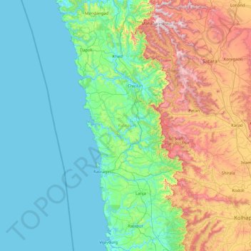
Name: Ratnagiri topographic map, elevation, terrain.
Location: Ratnagiri, Maharashtra, India (16.49399 73.02847 18.07151 73.86386)
Average elevation: 301 m
Minimum elevation: -2 m
Maximum elevation: 1,434 m
Other topographic maps
Click on a map to view its topography, its elevation and its terrain.
Chinchwad
India > Maharashtra > Chinchwad
Chinchwad, Kolhapur, Maharashtra, 416112, India
Average elevation: 548 m
Karjat
India > Maharashtra > Karjat
Karjat, Kulāba, Raigad, Maharashtra, 410201, India
Average elevation: 109 m
Zone 3
India > Maharashtra > Yamuna Nagar
Zone 3, Yamuna Nagar, Mumbai Suburban, Maharashtra, 400102, India
Average elevation: 7 m