
Powell County topographic map
Interactive map
Click on the map to display elevation.
About this map
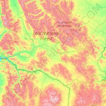
Name: Powell County topographic map, elevation, terrain.
Location: Powell County, Montana, United States (46.26564 -113.47182 47.60108 -112.29330)
Average elevation: 1,688 m
Minimum elevation: 974 m
Maximum elevation: 3,017 m
Other topographic maps
Click on a map to view its topography, its elevation and its terrain.
Cascade County
Cascade County, Montana, United States
Average elevation: 1,370 m
Flathead County
Flathead County, Montana, United States
Average elevation: 1,497 m
Missoula County
Missoula County, Montana, United States
Average elevation: 1,474 m