
Samosir topographic map
Interactive map
Click on the map to display elevation.
About this map
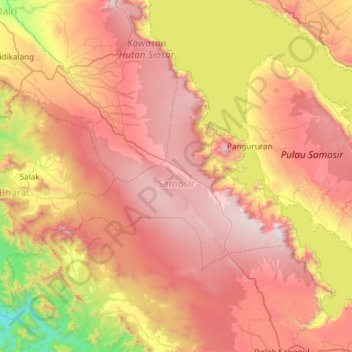
Name: Samosir topographic map, elevation, terrain.
Location: Samosir, North Sumatra, Indonesia (2.35196 98.39956 2.76040 98.99287)
Average elevation: 1,214 m
Minimum elevation: 212 m
Maximum elevation: 2,126 m
Other topographic maps
Click on a map to view its topography, its elevation and its terrain.
Dolok Simanukmanuk
Indonesia > North Sumatra > Pematang Siantar
Dolok Simanukmanuk, Pematang Siantar, North Sumatra, Indonesia
Average elevation: 1,785 m
Tebing Tinggi
Indonesia > North Sumatra > Tebing Tinggi
Tebing Tinggi, Kota Tebing Tinggi–Serdang Bedagai, North Sumatra, 20600, Indonesia
Average elevation: 34 m