
Каратор topographic map
Interactive map
Click on the map to display elevation.
About this map
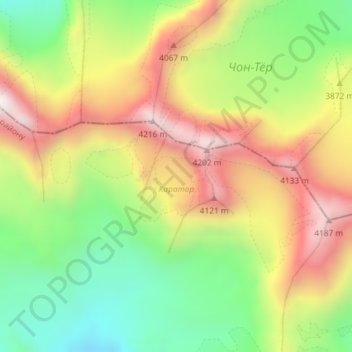
Name: Каратор topographic map, elevation, terrain.
Location: Каратор, Sokuluk District, Chuy Region, Kyrgyzstan (42.43005 74.32536 42.43681 74.34235)
Average elevation: 3,779 m
Minimum elevation: 3,397 m
Maximum elevation: 4,203 m
Other topographic maps
Click on a map to view its topography, its elevation and its terrain.
СК Связист
Kyrgyzstan > Chuy Region > СК Связист
СК Связист, Sokuluk District, Chuy Region, Kyrgyzstan
Average elevation: 636 m
Ysyk-Ata River
Ysyk-Ata River, Ysyk-Ata District, Chuy Region, Kyrgyzstan
Average elevation: 691 m
Chuy
Kyrgyzstan > Chuy Region > Chuy
Chuy, Чуйский район, Chuy Region, Kyrgyzstan
Average elevation: 822 m