
Godavari topographic map
Interactive map
Click on the map to display elevation.
About this map
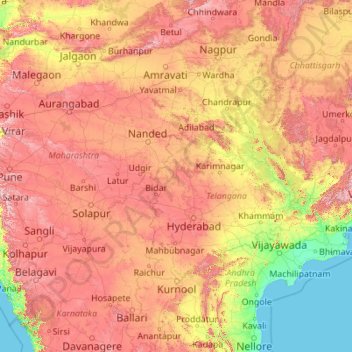
Name: Godavari topographic map, elevation, terrain.
Location: Godavari, Navipet mandal, Nizamabad, Telangana, 504205, India (16.68053 73.53222 20.05143 82.35356)
Average elevation: 380 m
Minimum elevation: -2 m
Maximum elevation: 1,440 m
Other topographic maps
Click on a map to view its topography, its elevation and its terrain.
Hyderabad
India > Telangana > Bahadurpura mandal
Hyderabad, Bahadurpura mandal, Hyderabad District, Telangana, India
Average elevation: 549 m
Gurudev Nagar
India > Telangana > Gurudev Nagar
Gurudev Nagar, Boath mandal, Adilabad, Telangana, India
Average elevation: 467 m