
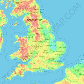
England topographic map
Interactive map
Click on the map to display elevation.
About this map
Name: England topographic map, elevation, terrain.
Location: England, United Kingdom (49.67400 -6.70475 55.91700 2.09191)
Average elevation: 55 m
Minimum elevation: -3 m
Maximum elevation: 966 m
Other topographic maps
Click on a map to view its topography, its elevation and its terrain.
City of London
United Kingdom > England > City of London > City of London
City of London, England, EC2V 5AE, United Kingdom
Average elevation: 42 m
Shrewsbury
United Kingdom > England > Shrewsbury
Shrewsbury, Shropshire, West Midlands, England, SY1 1SF, United Kingdom
Average elevation: 71 m
Water
United Kingdom > England > Devon > Teignbridge
Water, Teignbridge, Devon, England, TQ13 9UE, United Kingdom
Average elevation: 261 m
Stonehenge
United Kingdom > England > Larkhill
Stonehenge, The Avenue, Amesbury, Larkhill, Wiltshire, South West England, England, SP3 4DX, United Kingdom
Average elevation: 99 m
Montgomery
United Kingdom > Wales > Powys
Montgomery, Powys, Wales, SY15 6PY, United Kingdom
Average elevation: 145 m
Northampton
United Kingdom > England > West Northamptonshire > Northampton
Northampton, West Northamptonshire, England, United Kingdom
Average elevation: 89 m
Hadfield
United Kingdom > England > Derbyshire > High Peak
Hadfield, High Peak, Derbyshire, England, United Kingdom
Average elevation: 174 m
London
London, Greater London, England, United Kingdom
Average elevation: 66 m
Alvescot
United Kingdom > England > Oxfordshire > West Oxfordshire
Alvescot, West Oxfordshire, Oxfordshire, England, United Kingdom
Average elevation: 87 m
Derbyshire Dales
United Kingdom > England > Derbyshire
Derbyshire Dales, Derbyshire, England, United Kingdom
Average elevation: 198 m
Sunderland
Sunderland, North East, England, United Kingdom
Average elevation: 46 m
Welford
United Kingdom > England > West Berkshire
Welford, West Berkshire, England, United Kingdom
Average elevation: 124 m
Hazelwood CP
United Kingdom > England > Derbyshire > Amber Valley
Hazelwood CP, Amber Valley, Derbyshire, England, United Kingdom
Average elevation: 110 m
Alfreton Park
United Kingdom > England > Derbyshire > Amber Valley > Alfreton CP > Oakerthorpe
Alfreton Park, Alfreton CP, Oakerthorpe, Amber Valley, Derbyshire, England, DE55 7AL, United Kingdom
Average elevation: 116 m
Great Shefford
United Kingdom > England > West Berkshire
Great Shefford, West Berkshire, England, United Kingdom
Average elevation: 148 m
Middleton Cheney
United Kingdom > England > West Northamptonshire
Middleton Cheney, West Northamptonshire, England, United Kingdom
Average elevation: 128 m
Heamoor
United Kingdom > England > Cornwall > Penzance
Heamoor, Penzance, Cornwall, England, TR18 3GD, United Kingdom
Average elevation: 70 m
Yorkshire Dales National Park
Yorkshire Dales National Park, England, United Kingdom
Average elevation: 298 m
Amport
United Kingdom > England > Hampshire > Test Valley
Amport, Test Valley, Hampshire, England, United Kingdom
Average elevation: 95 m
Brook
United Kingdom > England > Hampshire > New Forest > Bramshaw
Brook, Bramshaw, New Forest, Hampshire, England, SO43 7HE, United Kingdom
Average elevation: 65 m
Crediton
United Kingdom > England > Devon > Mid Devon
Crediton, Mid Devon, Devon, England, United Kingdom
Average elevation: 71 m
Stapleford Abbotts
United Kingdom > England > Epping Forest
Stapleford Abbotts, Epping Forest, Essex, England, United Kingdom
Average elevation: 59 m
River Glen
United Kingdom > England > Northumberland > Kirknewton
River Glen, Kirknewton, Northumberland, North of Tyne, England, United Kingdom
Average elevation: 97 m
Selattyn
United Kingdom > England > Shropshire
Selattyn, Shropshire, England, SY10 7EZ, United Kingdom
Average elevation: 242 m
Down Ampney
United Kingdom > England > Gloucestershire > Cotswold District
Down Ampney, Cotswold District, Gloucestershire, England, GL7 5QR, United Kingdom
Average elevation: 85 m
Cusworth
United Kingdom > England > Doncaster
Cusworth, Doncaster, South Yorkshire, England, DN5 8UZ, United Kingdom
Average elevation: 25 m
The Swag
United Kingdom > England > Walsall > Shelfield > Stubbers Green
The Swag, Barn's Lane, Stubbers Green, Shelfield, Walsall, West Midlands Combined Authority, England, United Kingdom
Average elevation: 143 m
Buckover
United Kingdom > England > South Gloucestershire > Thornbury > Milbury Heath
Buckover, Milbury Heath, Thornbury, South Gloucestershire, West of England, England, GL12 8DX, United Kingdom
Average elevation: 65 m
Cambourne
United Kingdom > England > Cambridgeshire > South Cambridgeshire
Cambourne, South Cambridgeshire, Cambridgeshire, Cambridgeshire and Peterborough, England, United Kingdom
Average elevation: 63 m
Red Lodge
United Kingdom > England > Suffolk > West Suffolk
Red Lodge, West Suffolk, Suffolk, England, United Kingdom
Average elevation: 22 m
River Esk
United Kingdom > England > North Yorkshire
River Esk, North Yorkshire, England, United Kingdom
Average elevation: 189 m
Burn
United Kingdom > England > Norfolk > King's Lynn and West Norfolk > Burnham Overy
Burn, Burnham Overy, King's Lynn and West Norfolk, Norfolk, England, PE31 8DX, United Kingdom
Average elevation: 16 m
Rotherham
Rotherham, South Yorkshire Mayoral Combined Authority, England, United Kingdom
Average elevation: 101 m
Scottish Highlands
United Kingdom > Scotland > Highland
Scottish Highlands, Highland, Scotland, United Kingdom
Average elevation: 907 m
Royal Leamington Spa
United Kingdom > England > Royal Leamington Spa
Royal Leamington Spa, Warwickshire, West Midlands, England, CV32 4DB, United Kingdom
Average elevation: 68 m
Killyberry Boyd
United Kingdom > Northern Ireland
Killyberry Boyd, Northern Ireland, United Kingdom
Average elevation: 35 m
Lew
United Kingdom > England > Oxfordshire > West Oxfordshire
Lew, West Oxfordshire, Oxfordshire, England, United Kingdom
Average elevation: 79 m
Evershot
United Kingdom > England > Dorset
Evershot, Dorset, England, United Kingdom
Average elevation: 156 m
Muckleford
United Kingdom > England > Dorset > Grimstone
Muckleford, Bradford Peverell, Grimstone, Dorset, England, DT2 9SW, United Kingdom
Average elevation: 114 m
Wool
United Kingdom > England > Dorset > Bovington
Wool, Bovington, Dorset, England, United Kingdom
Average elevation: 37 m
Pinewoods
United Kingdom > England > North Yorkshire > Harrogate
Pinewoods, Duchy, Harrogate, North Yorkshire, England, United Kingdom
Average elevation: 139 m
Nappa
United Kingdom > England > North Yorkshire > Halton West
Nappa, Hellifield, Halton West, North Yorkshire, England, BD23 4LT, United Kingdom
Average elevation: 154 m
Hilltown
United Kingdom > Northern Ireland > County Down
Hilltown, County Down, Northern Ireland, BT34 5UH, United Kingdom
Average elevation: 136 m
West Tytherley
United Kingdom > England > Hampshire > Test Valley
West Tytherley, Test Valley, Hampshire, England, United Kingdom
Average elevation: 73 m
White City
United Kingdom > England > Gloucestershire > Gloucester
White City, Gloucester, Gloucestershire, England, GL4 6UL, United Kingdom
Average elevation: 38 m
Derehams Park
United Kingdom > England > Buckinghamshire > Loudwater
Derehams Park, Rayners Avenue Mobile Home Park, Chepping Wycombe, Beaconsfield and Chepping Wye Community Board, Loudwater, Buckinghamshire, England, United Kingdom
Average elevation: 95 m
Goblin Ledge
United Kingdom > England > South Gloucestershire > Severn Beach > New Passage
Goblin Ledge, Prince of Wales Bridge, New Passage, Pilning and Severn Beach, Severn Beach, South Gloucestershire, West of England, England, BS35 4NQ, United Kingdom
Average elevation: 2 m
Milburn
United Kingdom > England > Westmorland and Furness
Milburn, Westmorland and Furness, England, United Kingdom
Average elevation: 320 m
Willington Quay
United Kingdom > England > North Tyneside > Wallsend
Willington Quay, Howdon, Wallsend, North Tyneside, North of Tyne, England, NE28 6EA, United Kingdom
Average elevation: 23 m