
Florida topographic map
Interactive map
Click on the map to display elevation.
Florida
Florida's topography is characterized by its predominantly flat landscape, with the highest elevation being Britton Hill at just 345 feet (105 meters) above sea level, making it the lowest high point of any U.S. state. The state is primarily divided into three physiographic regions: the Atlantic Coastal Plain, the East Gulf Coastal Plain, and the Florida Uplands. The coastal plains feature sandy beaches, wetlands, and barrier islands along both the Atlantic Ocean and the Gulf of Mexico, supporting diverse ecosystems, including the famous Florida Keys. In contrast, the Florida Uplands, located in the central part of the state, are marked by rolling hills and extensive pine forests, creating a slight elevation compared to the coastal regions. Florida is also home to numerous lakes, such as Lake Okeechobee, and a vast network of wetlands, including the Everglades, which play a critical role in local ecosystems and water management.
About this map
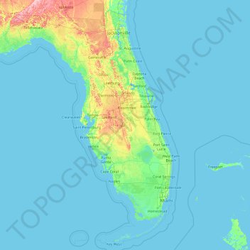
Name: Florida topographic map, elevation, terrain.
Location: Florida, United States (24.39631 -87.63490 31.00076 -79.97431)
Average elevation: 6 m
Minimum elevation: -3 m
Maximum elevation: 111 m
Other topographic maps
Click on a map to view its topography, its elevation and its terrain.
Baltimore
United States > Maryland > Baltimore
Baltimore is in north-central Maryland on the Patapsco River close to where it empties into the Chesapeake Bay. The city is also located on the fall line between the Piedmont Plateau and the Atlantic coastal plain, which divides Baltimore into "lower city" and "upper city". The city's elevation ranges from sea…
Average elevation: 65 m
Little Bear Island
United States > New Hampshire > Carroll County > Tuftonboro
Average elevation: 160 m
Sierra Blanca
United States > Texas > Hudspeth County
Sierra Blanca is found in Far West Texas, a subdivision of West Texas, and is 4,520 feet (1,380 m) above sea level. The town is part of the Trans-Pecos region within the most mountainous and arid portion of Texas. The town is located in Hudspeth County, which is large and sparsely populated. Sierra Blanca…
Average elevation: 1,391 m
Rocky Mountains
United States > Wyoming > Teton County
Agriculture and forestry are major industries. Agriculture includes dryland and irrigated farming and livestock grazing. Livestock are frequently moved between high-elevation summer pastures and low-elevation winter pastures, a practice known as transhumance.
Average elevation: 2,292 m
Scottsdale
United States > Arizona > Maricopa County > Scottsdale
The city is in the Salt River Valley, or the "Valley of the Sun," in the northern reaches of the Sonoran Desert. Scottsdale, 31 mi (50 km) long and 11.4 mi (18.3 km) wide at its widest point, shares boundaries with many other municipalities and entities. On the west, Scottsdale is bordered by Phoenix, Paradise…
Average elevation: 414 m
Columbus
United States > Ohio > Franklin County > Columbus
The confluence of the Scioto and Olentangy rivers is just north-west of Downtown Columbus. Several smaller tributaries course through the Columbus metropolitan area, including Alum Creek, Big Walnut Creek, and Darby Creek. Columbus is considered to have relatively flat topography thanks to a large glacier that…
Average elevation: 255 m
Wesley Chapel
United States > Florida > Pasco County
According to the United States Census Bureau, the CDP has a total area of 6.1 square miles (16 km2), of which 6.1 square miles (16 km2) is land and 0.04 square miles (0.10 km2) (0.49%) is water. The elevation is about 100 feet (30 m), combined with an inland location, creates more temperature variation in the…
Average elevation: 19 m
Appalachian Mountains
United States > North Carolina > Yancey County
The Appalachian Mountains (French: Appalaches), often called the Appalachians, are a system of mountains in eastern to northeastern North America. The Appalachians first formed roughly 480 million years ago during the Ordovician Period. They once reached elevations similar to those of the Alps and the Rocky…
Average elevation: 1,463 m
San Diego
United States > California > San Diego County > San Diego
The climate in San Diego, like most of Southern California, often varies significantly over short geographical distances, resulting in microclimates. In San Diego, this is mostly because of the city's topography (the Bay, and the numerous hills, mountains, and canyons). Frequently, particularly during the "May…
Average elevation: 57 m
San Francisco Bay Area
United States > California > San Francisco
The San Francisco Bay Area is characterized by a diverse and dynamic topography shaped by geological processes over millions of years. This region features a combination of coastal plains, steep hills, and rugged mountains, all influenced by the tectonic activity associated with the nearby San Andreas Fault…
Average elevation: 113 m
Central Park
United States > New York > New York County > New York
In June 1856, Fernando Wood appointed a "consulting board" of seven people, headed by author Washington Irving, to inspire public confidence in the proposed development. Wood hired military engineer Egbert Ludovicus Viele as the park's chief engineer, tasking him with a topographical survey of the site. The…
Average elevation: 26 m
Nineacre Island
United States > New Hampshire > Carroll County > Moultonborough
Average elevation: 158 m
Silver Beach
United States > Connecticut > South Central Connecticut Planning Region > Milford
Average elevation: 5 m
Chimney Point
United States > Connecticut > Western Connecticut Planning Region > New Milford
Average elevation: 142 m
Anna Maria island
United States > Florida > Manatee County
Anna Maria Island features a flat, sandy topography typical of a barrier island on the Gulf Coast. With an average elevation of around 15 feet above sea level, the terrain includes broad beaches, low dunes, and narrow stretches of sandy soil, making it highly vulnerable to storm surges and tidal flooding. The…
Average elevation: 2 m
Beartrap Lake
United States > Wisconsin > Washburn County > Town of Birchwood
Average elevation: 431 m
Drakeville
United States > Connecticut > Northwest Hills Planning Region > Torrington
Average elevation: 309 m
Central Highlands
United States > Pennsylvania > Allegheny County > Elizabeth Township
Average elevation: 327 m
West Saint Johnsville
United States > New York > Montgomery County > Town of Saint Johnsville
Average elevation: 151 m
Grand Staircase
United States > Connecticut > Northwest Hills Planning Region > Kent
Average elevation: 205 m
Farmdale
United States > Pennsylvania > Lancaster County > West Hempfield Township
Average elevation: 131 m
Georgetown
United States > Texas > Georgetown
The city is located on the northeastern edge of Texas Hill Country. Portions of Georgetown are located on either side of the Balcones Escarpment, a fault line in which the areas roughly east of IH-35 are flat and characterized by having black, fertile soils of the Blackland Prairie, and the west side of the…
Average elevation: 219 m
Mount Baldhead
United States > Michigan > Allegan County > Saugatuck
Mount Baldhead, also known as Mt. Baldy and Radar Hill, is a 250-foot (76-meter) sand dune located on a narrow strip of land between Lake Michigan and Kalamazoo River, directly across the river from downtown Saugatuck. It has an elevation of 807 feet (246 meters) and is about 70 miles (110 kilometers) north of…
Average elevation: 184 m
Crested Butte
United States > Colorado > Gunnison County
Crested Butte is located in north-central Gunnison County on the west side of the valley of the Slate River, along Coal Creek. Colorado State Highway 135 runs south from Crested Butte 27 miles (43 km) to Gunnison, the county seat. According to the United States Census Bureau, the town of Crested Butte has a…
Average elevation: 2,798 m
Jensen Beach
United States > Florida > Martin County
The Skyline Drive area includes some of the highest points in the community, reaching an elevation of 70 feet (21 m) at one point.
Average elevation: 5 m
Navarre
United States > Florida > Santa Rosa County
Navarre is located at 30°24′04″N 86°51′47″W / 30.401°N 86.863°W / 30.401; -86.863Coordinates: 30°24′04″N 86°51′47″W / 30.401°N 86.863°W / 30.401; -86.863. It is located within a portion of the Florida Panhandle observing the Central Time Zone. Elevation is at an average of 10 feet (3.0 m).
Average elevation: 4 m
Bolinas
United States > California > Marin County
Bolinas sits at an elevation of 36 feet (11 m) above sea level. It is bound on the northeast by Bolinas Lagoon and Kent Island, on the south by Bolinas Bay and Duxbury Point, on the southwest by the Pacific Ocean, and on the northwest by Point Reyes National Seashore. According to the United States Census…
Average elevation: 28 m
Mount Hood
United States > Oregon > Hood River County
Timberline Lodge is a National Historic Landmark located on the southern flank of Mount Hood just below Palmer Glacier, with an elevation of about 6,000 ft (1,800 m).
Average elevation: 2,716 m
Mauna Kea
United States > Hawaii > Hawaiʻi County
Mauna Kea (/ˌmaʊnə ˈkeɪə/; Hawaiian: [ˈmɐwnə ˈkɛjə]; abbreviation for Mauna a Wākea) is a dormant volcano on the island of Hawaiʻi. Its peak is 4,207.3 m (13,803 ft) above sea level, making it the highest point in the state of Hawaiʻi and second-highest peak of an island on Earth. The peak is…
Average elevation: 3,978 m
Mount Washington
United States > New Hampshire > Coos County
Mount Washington, also known as Agiocochook, is an ultra-prominent mountain in the state of New Hampshire. It is the highest peak in the Northeastern United States at 6,288.2 ft (1,916.6 m) and the most topographically prominent mountain east of the Mississippi River.
Average elevation: 1,568 m
Saugatuck
United States > Connecticut > Western Connecticut Planning Region > Westport
Average elevation: 15 m
North Mianus
United States > Connecticut > Western Connecticut Planning Region > Greenwich
Average elevation: 32 m