
Mount Batur topographic map
Interactive map
Click on the map to display elevation.
About this map
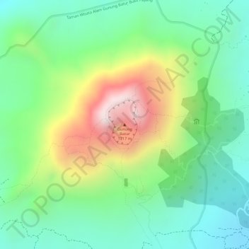
Name: Mount Batur topographic map, elevation, terrain.
Location: Mount Batur, Bali, Indonesia (-8.23947 115.37791 -8.23937 115.37801)
Average elevation: 1,301 m
Minimum elevation: 1,074 m
Maximum elevation: 1,693 m
Other topographic maps
Click on a map to view its topography, its elevation and its terrain.
Pulau Bali
Bali's central mountains include several peaks over 2,000 metres (6,600 feet) in elevation and active volcanoes such as Mount Batur. The highest is Mount Agung (3,031 m, 9,944 ft), known as the "mother mountain", which is an active volcano rated as one of the world's most likely sites for a massive eruption…
Average elevation: 122 m
Penida Island
Indonesia > Bali > Klungkung Regency > Batukandik
Nusa Penida (Balinese: ᬦᬸᬲᬧᭂᬦᬶᬤ, romanized: Nusa Penida, lit. 'Penida Island') is an island located near the southeastern Indonesian island of Bali and a district of Klungkung Regency that includes the neighbouring small island of Nusa Lembongan and twelve even smaller islands. The Badung…
Average elevation: 104 m
Denpasar
Denpasar is located at an elevation of 4 m (13 ft) above sea level. While the total area of 127.78 km2 or 2.18% of the total area of Bali Province. From the use of land, 2,768 hectares of land are paddy, 10,001 hectares are dry land, while the remaining land area is 9 hectares.
Average elevation: 7 m