
Bell County topographic map
Interactive map
Click on the map to display elevation.
About this map
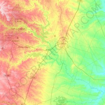
Name: Bell County topographic map, elevation, terrain.
Location: Bell County, Texas, United States (30.75237 -97.91371 31.32011 -97.07003)
Average elevation: 202 m
Minimum elevation: 99 m
Maximum elevation: 366 m
Other topographic maps
Click on a map to view its topography, its elevation and its terrain.
Harlingen
United States > Texas > Cameron County
Harlingen, Cameron County, Texas, 78550, United States
Average elevation: 14 m
Rotan
United States > Texas > Fisher County
Rotan, Fisher County, Texas, 79546, United States
Average elevation: 598 m
The Vistas
United States > Texas > Ector County > Odessa
The Vistas, Odessa, Ector County, Texas, 79765, United States
Average elevation: 882 m