
Saint Mary's County topographic map
Interactive map
Click on the map to display elevation.
About this map
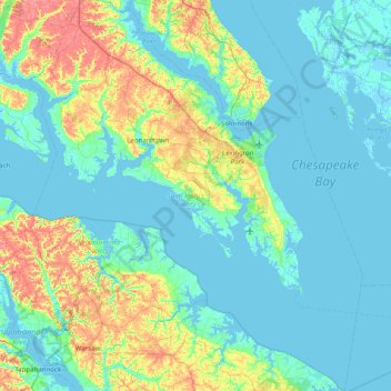
Name: Saint Mary's County topographic map, elevation, terrain.
Location: Saint Mary's County, Maryland, United States (37.89033 -76.87435 38.51371 -76.19967)
Average elevation: 13 m
Minimum elevation: -4 m
Maximum elevation: 62 m
Other topographic maps
Click on a map to view its topography, its elevation and its terrain.
Walkersville
United States > Maryland > Frederick County
Walkersville, Frederick County, Maryland, 21793, United States
Average elevation: 99 m
Picardy
United States > Maryland > Picardy
Picardy, Allegany County, Maryland, United States
Average elevation: 251 m