
Nsanje topographic map
Interactive map
Click on the map to display elevation.
About this map
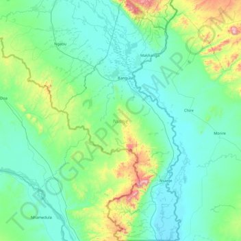
Name: Nsanje topographic map, elevation, terrain.
Location: Nsanje, Southern Region, Malawi (-17.12960 34.89497 -16.31016 35.31473)
Average elevation: 172 m
Minimum elevation: 31 m
Maximum elevation: 965 m
Nsanje is the southernmost district in Malawi and lies in the Lower Shire River Valley. It straddles the Shire River in the north (the river forms most of Nsanje’s eastern boundary) and is surrounded by Mozambique. Elevation is around 200 feet (61 m) ASL except for some hills in the south-western part of the district which reach near to 2,000 feet (610 m) ASL. Mwabvi Game Reserve lies in the north-western part of the district and can be accessed from Bangula or Sorgin (both along the M-1 road) Elephant Marsh lies partially in the northern part of the district and can be accessed for tours via the eastern bank road. Tours start from the village of James.