
Katete topographic map
Interactive map
Click on the map to display elevation.
About this map
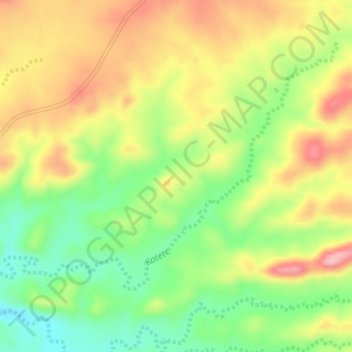
Name: Katete topographic map, elevation, terrain.
Location: Katete, Hwange, Matabeleland North, Zimbabwe (-18.34125 27.09959 -18.31390 27.13786)
Average elevation: 919 m
Minimum elevation: 844 m
Maximum elevation: 998 m
Other topographic maps
Click on a map to view its topography, its elevation and its terrain.
Sengwa River
Sengwa River, Matabeleland North, Zimbabwe
Average elevation: 797 m
Victoria Falls National Park
Zimbabwe > Matabeleland North > Victoria Falls
Victoria Falls National Park, Pioneer Road, Victoria Falls, Hwange, Matabeleland North, 00236, Zimbabwe
Average elevation: 913 m
Hwange
Hwange, Matabeleland North, 00236, Zimbabwe
Average elevation: 968 m
Katete
Katete, Hwange, Matabeleland North, Zimbabwe
Average elevation: 950 m