
Crook County topographic map
Interactive map
Click on the map to display elevation.
About this map
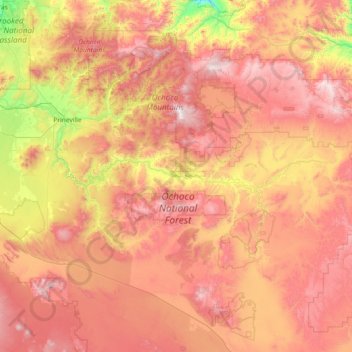
Name: Crook County topographic map, elevation, terrain.
Location: Crook County, Oregon, United States (43.69748 -121.10864 44.56395 -119.65489)
Average elevation: 1,339 m
Minimum elevation: 614 m
Maximum elevation: 2,099 m
Other topographic maps
Click on a map to view its topography, its elevation and its terrain.
Hood River County
Hood River County, Oregon, United States
Average elevation: 860 m
Beaverton
United States > Oregon > Beaverton
Beaverton, Washington County, Oregon, United States
Average elevation: 106 m