
Monroe County topographic map
Interactive map
Click on the map to display elevation.
About this map
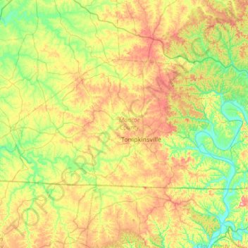
Name: Monroe County topographic map, elevation, terrain.
Location: Monroe County, Kentucky, United States of America (36.61499 -85.97704 36.84161 -85.43633)
Average elevation: 250 m
Minimum elevation: 156 m
Maximum elevation: 414 m
Other topographic maps
Click on a map to view its topography, its elevation and its terrain.
Green County
United States of America > Kentucky
Green County, Kentucky, United States of America
Average elevation: 230 m
Nelse
United States of America > Kentucky > Nelse
Nelse, Pike County, Kentucky, 41562, United States of America
Average elevation: 315 m
Dawkins
United States of America > Kentucky > Dawkins
Dawkins, Johnson County, Kentucky, 41268, United States of America
Average elevation: 238 m
Edmonson County
United States of America > Kentucky
Edmonson County, Kentucky, United States of America
Average elevation: 196 m