
Dakshina Kannada topographic map
Interactive map
Click on the map to display elevation.
About this map
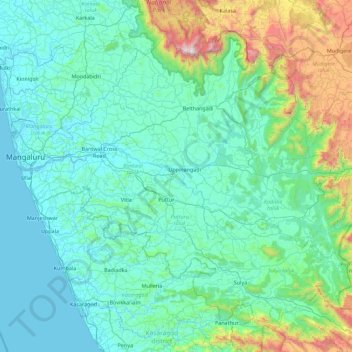
Name: Dakshina Kannada topographic map, elevation, terrain.
Location: Dakshina Kannada, Karnataka, India (12.45890 74.77687 13.18383 75.67332)
Average elevation: 259 m
Minimum elevation: -2 m
Maximum elevation: 1,862 m
The topography of the district is plain up to 30 km (18.64 mi) inside the coast and changes to undulating hilly terrain sharply towards the east in the Western Ghats. Teak, bamboo and rosewood trees are found in the hilly areas towards the east. The Geological Survey of India has identified this district as a moderately earthquake-prone region and categorised it in the Seismic III Zone. In rural Dakshina Kannada, houses are in the midst of a farm field or plantations of coconut or arecanut, separated by a few hundred metres.
Other topographic maps
Click on a map to view its topography, its elevation and its terrain.
Kamalapura
India > Karnataka > Kamalapura
Kamalapura, Hosapete taluk, Bellary district, Karnataka, 583221, India
Average elevation: 456 m
Baba Budangiri
India > Karnataka > Chikkamagaluru
Baba Budangiri, Chikkamagaluru, Chikkamagaluru taluku, Chikkamagaluru district, Karnataka, 577101, India
Average elevation: 1,628 m
Krishna River
Krishna River, Shahapura taluku, Yadagiri district, Karnataka, 412803, India
Average elevation: 413 m
Sampangiram Nagar Ward
Sampangiram Nagar Ward, East Zone, Bengaluru, Bangalore Urban, Karnataka, India
Average elevation: 916 m
Kumara Parvatha
Kumara Parvatha, Somawarpet taluk, Kodagu, Karnataka, India
Average elevation: 1,227 m
Hegganahalli
Hegganahalli, Dasarahalli Zone, Bengaluru, Bangalore Urban, Karnataka, India
Average elevation: 907 m
Tadiandamol
Tadiandamol, Madikeri taluku, Kodagu, Karnataka, India
Average elevation: 1,322 m
Chikmagalur
Chikmagalur, Chikkamagaluru district, Karnataka, India
Average elevation: 652 m