
Nashik topographic map
Interactive map
Click on the map to display elevation.
About this map
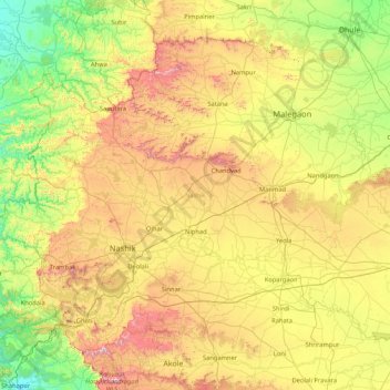
Name: Nashik topographic map, elevation, terrain.
Location: Nashik, Maharashtra, India (19.58638 73.25963 20.86368 74.93842)
Average elevation: 524 m
Minimum elevation: 41 m
Maximum elevation: 1,548 m
The entire Nashik district is underlain by the basaltic lava flows. These flows are normally horizontally disposed over a wide stretch and give rise to table land type of topography also known a plateau. These flows occur in layered sequences and represented by massive unit at the bottom and vesicular unit at the top of the flow. The shallow alluvial formation of recent age also occurs as narrow stretch along the banks of Godavari Rivers. The soils are the weathering products of Basalt and have various shades from gray to black, red and pink colour.
Other topographic maps
Click on a map to view its topography, its elevation and its terrain.
Chinchwad
India > Maharashtra > Chinchwad
Chinchwad, Kolhapur, Maharashtra, 416112, India
Average elevation: 548 m
Karjat
India > Maharashtra > Karjat
Karjat, Kulāba, Raigad, Maharashtra, 410201, India
Average elevation: 109 m
Zone 3
India > Maharashtra > Yamuna Nagar
Zone 3, Yamuna Nagar, Mumbai Suburban, Maharashtra, 400102, India
Average elevation: 7 m