
Iringa Region topographic map
Interactive map
Click on the map to display elevation.
Iringa Region
The elevation of Iringa varies from 900 to 2,300 meters above sea level. A significant scarp that can reach 800 meters in height and is the eastern portion of the Great Rift Valley surrounds the area on all sides. Iringa is hence situated in Tanzania's southern highlands, bordering Mbeya, Njombe, Morogoro, Dodoma, and Singida areas.
About this map
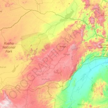
Name: Iringa Region topographic map, elevation, terrain.
Location: Iringa Region, Southern Highlands Zone, Tanzania (-9.04256 34.19411 -6.88860 36.84564)
Average elevation: 1,106 m
Minimum elevation: 242 m
Maximum elevation: 2,828 m
Other topographic maps
Click on a map to view its topography, its elevation and its terrain.
Dodoma
The official capital since 1996, Dodoma was envisaged as the first non-monumental capital city as opposed to the monumentality and hierarchy of other planned capital cities such as Abuja, Yamoussoukro, Brasília and Washington, D.C. It rejected geometrical forms such as grid iron and radial plans as…
Average elevation: 1,144 m
Arusha
Despite its proximity to the equator, Arusha's elevation of 1,400 metres (4,600 ft) on the southern slopes of Mount Meru keeps temperatures relatively low and alleviates humidity. Cool dry air is prevalent for much of the year. The temperature typically ranges between 10 and 30 °C (50 and 86 °F) with an…
Average elevation: 1,572 m
Mwanza
Mwanza features a tropical savanna climate under the Köppen climate classification. Temperatures are relatively consistent throughout the course of the year, tempered by the city's altitude. Thus, the climate is not quite as hot as one might expect, given the city's location near the equator. Average…
Average elevation: 1,178 m