
Franklin County topographic map
Interactive map
Click on the map to display elevation.
About this map
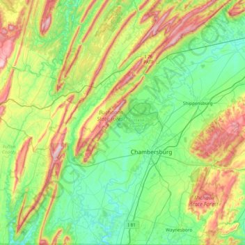
Name: Franklin County topographic map, elevation, terrain.
Location: Franklin County, Pennsylvania, United States of America (39.71982 -78.09923 40.29070 -77.45290)
Average elevation: 304 m
Minimum elevation: 127 m
Maximum elevation: 743 m
Other topographic maps
Click on a map to view its topography, its elevation and its terrain.
Lawrence County
United States of America > Pennsylvania
Lawrence County, Pennsylvania, United States of America
Average elevation: 338 m
Crawford County
United States of America > Pennsylvania
Crawford County, Pennsylvania, United States of America
Average elevation: 382 m
Philadelphia County
United States of America > Pennsylvania
Philadelphia County, Pennsylvania, United States of America
Average elevation: 39 m
Lehigh County
United States of America > Pennsylvania
Lehigh County, Pennsylvania, United States of America
Average elevation: 186 m
Bedford County
United States of America > Pennsylvania
Bedford County, Pennsylvania, United States of America
Average elevation: 491 m
Clinton County
United States of America > Pennsylvania
Clinton County, Pennsylvania, United States of America
Average elevation: 465 m
Delaware County
United States of America > Pennsylvania
Delaware County, Pennsylvania, United States of America
Average elevation: 76 m
Allegheny County
United States of America > Pennsylvania
Allegheny County, Pennsylvania, United States of America
Average elevation: 325 m