
Pierce County topographic map
Interactive map
Click on the map to display elevation.
About this map
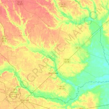
Name: Pierce County topographic map, elevation, terrain.
Location: Pierce County, Georgia, United States (31.20272 -82.42095 31.53081 -81.99245)
Average elevation: 37 m
Minimum elevation: 12 m
Maximum elevation: 61 m
Other topographic maps
Click on a map to view its topography, its elevation and its terrain.
Charlton County
Charlton County, Georgia, United States
Average elevation: 27 m
Ferrell Crossroads
United States > Georgia > Ferrell Crossroads
Ferrell Crossroads, Early County, Georgia, United States
Average elevation: 94 m