
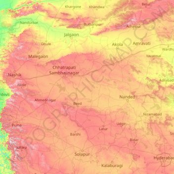
Maharashtra topographic map
Interactive map
Click on the map to display elevation.
About this map
Name: Maharashtra topographic map, elevation, terrain.
Location: Maharashtra, India (16.97193 73.49546 22.09193 78.61546)
Average elevation: 478 m
Minimum elevation: 3 m
Maximum elevation: 1,409 m
Maharashtra is the third largest state by area in India. The Western Ghats better known as Sahyadri, are a hilly range running parallel to the coast, at an average elevation of 1,200 metres (4,000 ft). Kalsubai, a peak in the Sahyadris, near Nashik city is the highest elevated point in Maharashtra. To the west of these hills lie the Konkan coastal plains, 50–80 kilometres in width. To the east of the Ghats lies the flat Deccan Plateau. Forests comprise 17% of the total area of the state. A majority of the forests are in the eastern and Sahyadri regions of the state. The main rivers of the state are Krishna, Bhima, Godavari, Tapi-Purna and Wardha-Wainganga. Since the central parts of the state receives low rainfall, most of the rivers in the region have multiple dams. Maharashtra has around 1821 notable large dams.
Other topographic maps
Click on a map to view its topography, its elevation and its terrain.
Chinchwad
India > Maharashtra > Chinchwad
Chinchwad, Kolhapur, Maharashtra, 416112, India
Average elevation: 548 m
Karjat
India > Maharashtra > Karjat
Karjat, Kulāba, Raigad, Maharashtra, 410201, India
Average elevation: 109 m
Zone 3
India > Maharashtra > Yamuna Nagar
Zone 3, Yamuna Nagar, Mumbai Suburban, Maharashtra, 400102, India
Average elevation: 7 m