
Nainital topographic map
Interactive map
Click on the map to display elevation.
About this map
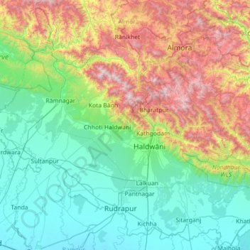
Name: Nainital topographic map, elevation, terrain.
Location: Nainital, Uttarakhand, India (28.97766 78.85049 29.61413 79.97577)
Average elevation: 777 m
Minimum elevation: 186 m
Maximum elevation: 2,593 m
Other topographic maps
Click on a map to view its topography, its elevation and its terrain.
Milam Glacier
Milam Glacier, Pithoragarh, Uttarakhand, India
Average elevation: 5,223 m
Pindar Glacier
Pindar Glacier, Bageshwar, Uttarakhand, India
Average elevation: 4,447 m
Pithoragarh
India > Uttarakhand > Pithoragarh
Pithoragarh, Uttarakhand, 262500, India
Average elevation: 1,618 m