
Sirohi topographic map
Interactive map
Click on the map to display elevation.
About this map
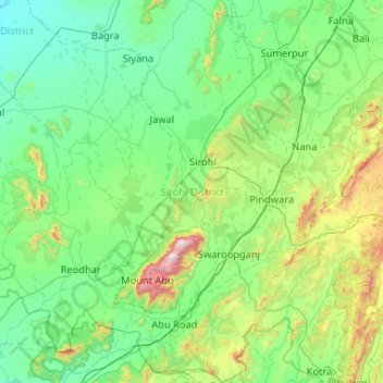
Name: Sirohi topographic map, elevation, terrain.
Location: Sirohi, Rajasthan, India (24.33736 72.24644 25.28431 73.17251)
Average elevation: 351 m
Minimum elevation: 109 m
Maximum elevation: 1,678 m
Sirohi District is broken up by hills and rocky ranges. The granite massif of Mount Abu divides the district into two portions, running from north-east to south-west. The south and south-east part of the district, which lies between Mount Abu and the main spine of the Aravallis, is mountainous and rugged, and is drained by the West Banas River. Abu Road, a station on the main Delhi-Ahmedabad rail line, lies in the valley of the West Banas. Dry deciduous forest is common in this part of the district, and the higher elevations of Mount Abu are covered in conifer forests. Abu Road is the biggest city and the main financial hub of Sirohi District. Sirohi district has the fewest villages in Rajasthan.
Other topographic maps
Click on a map to view its topography, its elevation and its terrain.
Guru Shikhar, Abu
Guru Shikhar, Abu, Abu Road Tehsil, Sirohi, Rajasthan, 307501, India
Average elevation: 1,366 m
Aravalli Range
Aravalli Range, Abu Road Tehsil, Sirohi, Rajasthan, 307501, India
Average elevation: 1,339 m