
Gulf of Saint Lawrence topographic map
Interactive map
Click on the map to display elevation.
About this map
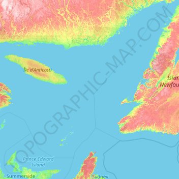
Name: Gulf of Saint Lawrence topographic map, elevation, terrain.
Location: Gulf of Saint Lawrence, Minganie, Côte-Nord, Quebec, Canada (45.58351 -66.37333 52.22285 -55.27019)
Average elevation: 167 m
Minimum elevation: -2 m
Maximum elevation: 1,173 m
Other topographic maps
Click on a map to view its topography, its elevation and its terrain.
Saint-Sauveur
Canada > Quebec > Saint-Sauveur
Saint-Sauveur, Les Pays-d'en-Haut, Laurentides, Quebec, Canada
Average elevation: 294 m
Rivière-des-Prairies–Pointe-aux-Trembles
Rivière-des-Prairies–Pointe-aux-Trembles, Montreal, Urban agglomeration of Montreal, Montreal (06), Quebec, Canada
Average elevation: 19 m
Côte-des-Neiges–Notre-Dame-de-Grâce
Côte-des-Neiges–Notre-Dame-de-Grâce, Montreal, Urban agglomeration of Montreal, Montreal (06), Quebec, Canada
Average elevation: 68 m
Lac Saint-Pierre
Canada > Quebec > Pierreville
Lac Saint-Pierre, Rang du Chenal-Tardif, Pierreville, Nicolet-Yamaska, Centre-du-Québec, Quebec, Canada
Average elevation: 25 m
Saint Lawrence River
Saint Lawrence River, Rue De Gaspé, Verdun, Montreal, Urban agglomeration of Montreal, Montreal (06), Quebec, H3E 1H2, Canada
Average elevation: 14 m
Lake Memphremagog
Lake Memphremagog, Chemin Girl's Camp, Potton, Memphrémagog, Estrie, Quebec, Canada
Average elevation: 311 m
Ville-Marie
Ville-Marie, Montreal, Urban agglomeration of Montreal, Montreal (06), Quebec, Canada
Average elevation: 30 m
René-Levasseur Island
Canada > Quebec > Rivière-aux-Outardes
René-Levasseur Island, Rivière-aux-Outardes, Manicouagan, Côte-Nord, Quebec, Canada
Average elevation: 474 m