
Towns County topographic map
Interactive map
Click on the map to display elevation.
About this map
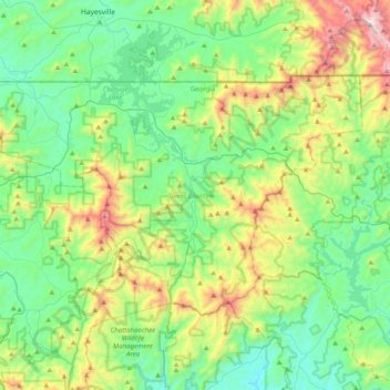
Name: Towns County topographic map, elevation, terrain.
Location: Towns County, Georgia, United States of America (34.79058 -83.94634 34.99240 -83.54668)
Average elevation: 764 m
Minimum elevation: 433 m
Maximum elevation: 1,657 m
Other topographic maps
Click on a map to view its topography, its elevation and its terrain.
Athens-Clarke County Unified Government
United States of America > Georgia > Athens-Clarke County Unified Government
Athens-Clarke County Unified Government, Athens-Clarke County, Georgia, United States of America
Average elevation: 220 m
Murray County
United States of America > Georgia
Murray County, Georgia, United States of America
Average elevation: 381 m
Barrow County
United States of America > Georgia
Barrow County, Georgia, United States of America
Average elevation: 261 m
Savannah
United States of America > Georgia > Savannah
Savannah, Chatham County, Georgia, United States of America
Average elevation: 4 m