
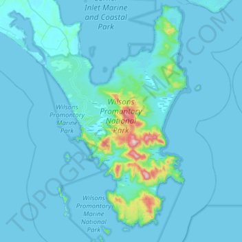
Wilsons Promontory National Park topographic map
Interactive map
Click on the map to display elevation.
About this map
Name: Wilsons Promontory National Park topographic map, elevation, terrain.
Average elevation: 32 m
Minimum elevation: -1 m
Maximum elevation: 734 m
Other topographic maps
Click on a map to view its topography, its elevation and its terrain.
Beechworth
Australia > Victoria > Beechworth
Beechworth, Shire of Indigo, Hume, Victoria, 3747, Australia
Average elevation: 533 m
Basalt Lake
Australia > Victoria > Harkaway
Basalt Lake, Board Walk, Berwick, Harkaway, City of Casey, Victoria, 3806, Australia
Average elevation: 76 m
Mount Dawson
Mount Dawson, Shire of East Gippsland, Gippsland, Victoria, Australia
Average elevation: 435 m
Croajingolong National Park
Croajingolong National Park, Lake Barracotta Link Track, Genoa, Shire of East Gippsland, Gippsland, Victoria, Australia
Average elevation: 50 m
Wilsons Promontory
Wilsons Promontory, Shire of South Gippsland, Gippsland, Victoria, Australia
Average elevation: 28 m
Wingan River
Wingan River, Shire of East Gippsland, Gippsland, Victoria, Australia
Average elevation: 131 m
Mount Feathertop
Mount Feathertop, Alpine Shire, Hume, Victoria, Australia
Average elevation: 1,533 m
Mount Fraser
Mount Fraser, Shire of Mitchell, Hume, Victoria, 3753, Australia
Average elevation: 309 m
Hattah - Kulkyne National Park
Australia > Victoria > Colignan
Hattah - Kulkyne National Park, Reed Road, Hattah, Colignan, Rural City of Mildura, Loddon Mallee, Victoria, Australia
Average elevation: 51 m
Badger Creek
Australia > Victoria > Healesville
Badger Creek, Healesville, Shire of Yarra Ranges, Victoria, Australia
Average elevation: 255 m