
Northeast Penang Island District topographic map
Interactive map
Click on the map to display elevation.
About this map
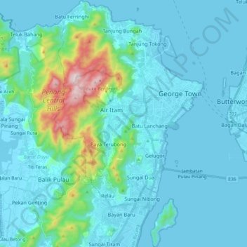
Name: Northeast Penang Island District topographic map, elevation, terrain.
Location: Northeast Penang Island District, Penang, Malaysia (5.30074 100.23528 5.48291 100.34663)
Average elevation: 99 m
Minimum elevation: -2 m
Maximum elevation: 804 m
Other topographic maps
Click on a map to view its topography, its elevation and its terrain.