
Thank you for supporting this site ❤️
Make a donation
Make a donation
Skamania County topographic map
Click on the map to display elevation.
Thank you for supporting this site ❤️
Make a donation
Make a donation
Skamania County
According to the United States Census Bureau, the county has a total area of 1,684 square miles (4,360 km2), of which 1,656 square miles (4,290 km2) is land and 28 square miles (73 km2), or 1.7%, is water. 90% of Skamania is forested and 80% is a part of Gifford Pinchot National Forest. The highest elevation in the county is 8,920 feet (2,720 m), on the slopes of Mount Adams, although prior to its eruption, Mount Saint Helens was the highest point at 9,677 feet (2,950 m).
Thank you for supporting this site ❤️
Make a donation
Make a donation
About this map
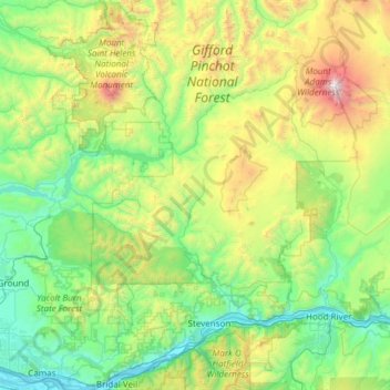
Name: Skamania County topographic map, elevation, terrain.
Location: Skamania County, Washington, United States (45.54858 -122.25023 46.38922 -121.51438)
Average elevation: 771 m
Minimum elevation: 0 m
Maximum elevation: 3,714 m
Thank you for supporting this site ❤️
Make a donation
Make a donation