Geolocate

Essex County topographic map

Interactive map

Click on the map to display elevation.

About this map

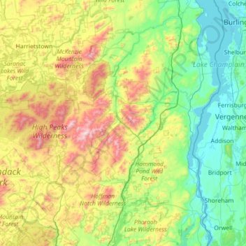
Name: Essex County topographic map, elevation, terrain.

Location: Essex County, New York, United States of America (43.74451 -74.33683 44.54861 -73.29338)

Average elevation: 418 m

Minimum elevation: 25 m

Maximum elevation: 1,607 m

Essex County is in the northeastern part of New York state, just west of Vermont along the eastern boundary of the state. The eastern boundary of Essex County is Lake Champlain, which serves as the New York – Vermont border at an elevation of just under 100 feet (30.5 m). The highest natural point in New York, Mount Marcy at 5,344 feet (1,629 m), is in the town of Keene.

Other topographic maps

Click on a map to view its topography, its elevation and its terrain.

Saratoga County

United States of America > New York

Saratoga County, New York, United States of America

Average elevation: 218 m

Farmingville

United States of America > New York

Farmingville, Suffolk County, New York, 11738, United States of America

Average elevation: 47 m

Queens

United States of America > New York > New York

Queens, New York, United States of America

Average elevation: 11 m

Saint Lawrence

United States of America > New York

Saint Lawrence, New York, United States of America

Average elevation: 239 m

Nassau County

United States of America > New York

Nassau County, New York, United States of America

Average elevation: 18 m

Allegany County

United States of America > New York

Allegany County, New York, United States of America

Average elevation: 561 m

Valley Stream

United States of America > New York > Valley Stream > Valley Stream

Valley Stream, Hempstead, Nassau County, New York, 11580, United States of America

Average elevation: 7 m

New York County

United States of America > New York > New York

New York County, New York, United States of America

Average elevation: 16 m