
Moreni topographic map
Interactive map
Click on the map to display elevation.
About this map
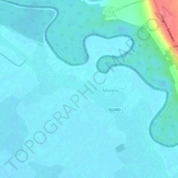
Name: Moreni topographic map, elevation, terrain.
Location: Moreni, Iași, 707392, Romania (47.08851 27.83810 47.11011 27.88141)
Average elevation: 38 m
Minimum elevation: 31 m
Maximum elevation: 102 m
Other topographic maps
Click on a map to view its topography, its elevation and its terrain.
Buzău
The city is located in the center of the county, 100 km north-east of Bucharest, in the south-east of Romania, taking up a total area of 81,3 km2, at the outermost curvature of the Subcarpathian foothills, at the crossroads of the three main Romanian historical provinces: Wallachia, Transylvania and Moldavia.…
Average elevation: 96 m
Bucharest
The city has an area of 226 km2 (87 sq mi). The altitude varies from 55.8 m (183.1 ft) at the Dâmbovița bridge in Cățelu, southeastern Bucharest and 91.5 m (300.2 ft) at the Militari church. The city has a roughly round shape, with the centre situated in the cross-way of the main north–south/east-west…
Average elevation: 82 m