Geolocate

Saint Lawrence topographic map

Interactive map

Click on the map to display elevation.

About this map

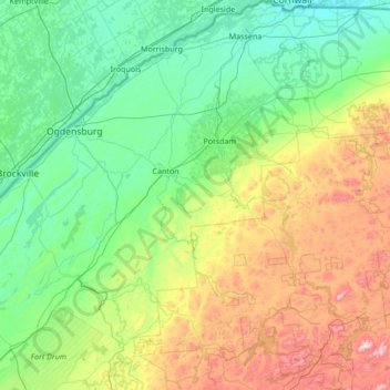
Name: Saint Lawrence topographic map, elevation, terrain.

Location: Saint Lawrence, New York, United States of America (44.05040 -75.86164 45.01586 -74.52526)

Average elevation: 239 m

Minimum elevation: 44 m

Maximum elevation: 929 m

Other topographic maps

Click on a map to view its topography, its elevation and its terrain.

Saratoga County

United States of America > New York

Saratoga County, New York, United States of America

Average elevation: 218 m

Farmingville

United States of America > New York

Farmingville, Suffolk County, New York, 11738, United States of America

Average elevation: 47 m

Queens

United States of America > New York > New York

Queens, New York, United States of America

Average elevation: 11 m

Essex County

United States of America > New York

Essex County, New York, United States of America

Average elevation: 418 m

Nassau County

United States of America > New York

Nassau County, New York, United States of America

Average elevation: 18 m

Allegany County

United States of America > New York

Allegany County, New York, United States of America

Average elevation: 561 m

Valley Stream

United States of America > New York > Valley Stream > Valley Stream

Valley Stream, Hempstead, Nassau County, New York, 11580, United States of America

Average elevation: 7 m

New York County

United States of America > New York > New York

New York County, New York, United States of America

Average elevation: 16 m