
Mutasa topographic map
Interactive map
Click on the map to display elevation.
About this map
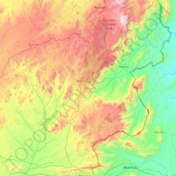
Name: Mutasa topographic map, elevation, terrain.
Location: Mutasa, Manicaland, Zimbabwe (-18.97345 32.39750 -18.20112 33.06835)
Average elevation: 1,262 m
Minimum elevation: 531 m
Maximum elevation: 2,565 m
Other topographic maps
Click on a map to view its topography, its elevation and its terrain.
Mount Nyangani
Mount Nyangani, Nyanga, Manicaland, Zimbabwe
Average elevation: 2,329 m