
Fox Creek topographic map
Interactive map
Click on the map to display elevation.
Fox Creek
Fox Creek is a town in northwest Alberta, Canada. It is located on Highway 43, approximately 259 km (161 mi) northwest of Edmonton and 199 km (124 mi) southeast of Grande Prairie, and has an elevation of 808 m (2,651 ft).
About this map
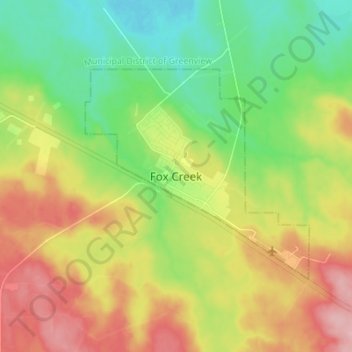
Name: Fox Creek topographic map, elevation, terrain.
Location: Fox Creek, Town of Fox Creek, Alberta, T0H 1P0, Canada (54.35721 -116.84338 54.43721 -116.76338)
Average elevation: 834 m
Minimum elevation: 776 m
Maximum elevation: 913 m