
Lawrence topographic map
Interactive map
Click on the map to display elevation.
Lawrence
Downtown Lawrence is located at 38°58′18″N 95°14′7″W / 38.97167°N 95.23528°W / 38.97167; -95.23528 (38.959902, −95.253199), approximately 25 miles (40 kilometers) east of Topeka, and 35 mi (56 km) west of Kansas City, Kansas. Though Lawrence has a designated elevation of 866 feet (264 m), the highest elevation is Mount Oread on the University of Kansas campus with an elevation of 1,020 feet (310 m).
About this map
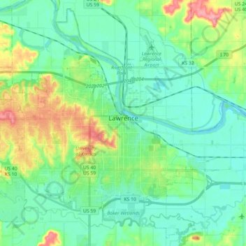
Name: Lawrence topographic map, elevation, terrain.
Location: Lawrence, Douglas County, Kansas, United States of America (38.90447 -95.34463 39.03350 -95.16662)
Average elevation: 265 m
Minimum elevation: 241 m
Maximum elevation: 333 m