
Smyth County topographic map
Interactive map
Click on the map to display elevation.
About this map
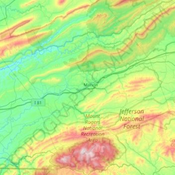
Name: Smyth County topographic map, elevation, terrain.
Location: Smyth County, Virginia, United States of America (36.63508 -81.83382 37.01715 -81.26219)
Average elevation: 852 m
Minimum elevation: 511 m
Maximum elevation: 1,730 m
Other topographic maps
Click on a map to view its topography, its elevation and its terrain.
Saltville
United States of America > Virginia > Saltville
Saltville, Smyth County, Virginia, 24370, United States of America
Average elevation: 617 m
Arlington County
United States of America > Virginia
Arlington County, Virginia, United States of America
Average elevation: 54 m
Augusta County
United States of America > Virginia
Augusta County, Virginia, United States of America
Average elevation: 570 m